Irun
Les Dossiers synthétiques et d'enjeux sont disponibles gratuitement.
Merci de vous inscrire et vous connecter pour accéder au Dossier complet de site.
- Dossier synthétique EN | ES
- Le site sur Google Maps
- Retour à la carte
Données synthétiques

Category Urban
Location Railway station zone. Irun, Guipúzcoa
Population 61,847 inhab.
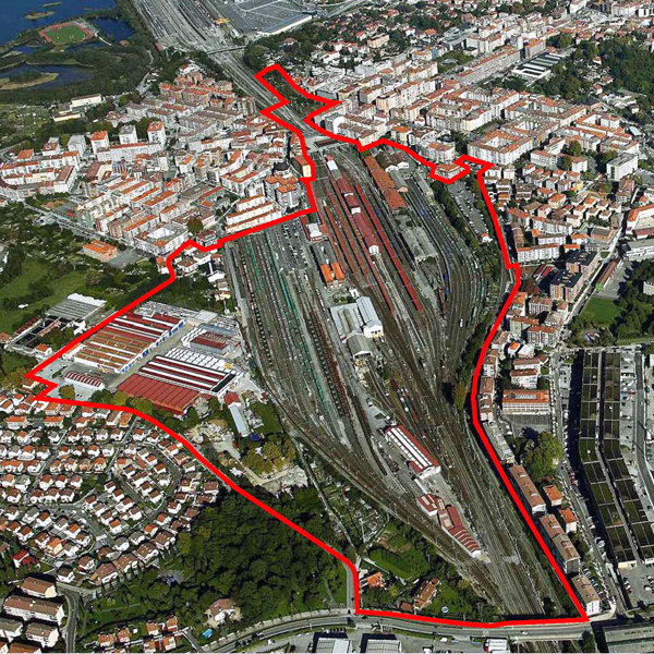
Project site 36.22 ha
Site proposed by Irun City Council
Owner(s) of the site Public (ADIF) and Private
Commision after competition Management of urban development project
Team representative architect - urban planner
Information complémentaire
How can the site contribute to the adaptable city?
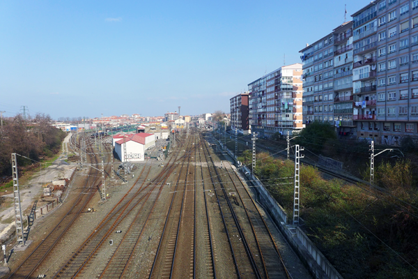
Irun's railway yards cover a large strip of land, cutting a spatial and functional gap through the central urban area, and spilling into Hendaye, across the French border. This space is crucial for the city given the enormous territorial implantation of the railway infrastructure in Irun.
Currently the two existing railway networks (owned by ADIF, ETS and Euskotren) are engaged in a process of renovation and remodelling in order to improve the standard of service for both passengers and freight in the context of the arrival of the TGV line and its Basque "Y" configuration. In this context, the new urban renewal project for the railway area is therefore viewed as a priority objective in order to improve the integration of the railway infrastructure into the urban environment, in consultation with the relevant authorities and public bodies.
City strategy
The urban strategy for the coming years is based on the following aspects:
1. The urban renewal of the railway zone on the basis of the definition of a new model that will integrate transport, urban environment and traffic policies, with a view to stimulating the recovery of urban spaces for pedestrians, cyclists and public transport.
2. The provision of new land alternatives for housing and business activities, making use of the plots still available within the town's urban fabric, helping to regenerate a degraded zone and replacing uses that may be problematic or annoying.
3. Finally, the harmonization and adaptation of the criteria for environmental protection and regulation: comprehensively protect the land zoned as undevelopable, and expand related facilities and services, i.e, parks, sports, educational, health, welfare and cultural services.
Site definition
The planning zone includes the railway area in the central part of Irun, a large swathe of land that divides the city into two, creating a deep spatial and functional split. The industrial land and apartment blocks on the western boundary of this space are also included in order to improve the integration of this space with the consolidated town.
This space primarily consists of the shunting yards and other railway facilities for which the Ministry of Development has commissioned technical and financial studies on their adaptation to future needs arising from the arrival of the TGV line to Irun, also envisaging the conversion of the current railway station into an intermodal transport station and the incorporation of the Basque Euskotren network.
The future Master Plan will define the compatibility or otherwise of each existing building and use with the envisaged plans on the basis of the Ministry of Development's technical studies on the adaptation of the railway facilities to the future requirements for this zone.
Future of the site in relation to the site family and Adaptability
The proposed urban transformation should reduce the railway's current footprint on the city, renovate the existing railway facilities, merge the Topo‐Euskotren train line with the current railway space, and give the city a new Services Centre, business activities and residential uses.
These objectives are linked to the desire to rationalise the operation of the railway zone, adapting it to the new requirements of the commuter service and the arrival of the TGV line, as described in the Protocol of Intent signed by the various public administrations.
This should significantly reduce the barrier imposed by the railway line running through the city, structuring a grid that will complement the existing urban fabric and satisfactorily resolve the road and functional connections on either side of the railway tracks and between neighbouring districts which until now have been separated physically.
Considering the new central character desired for this set of initiatives, the Master Plan is intended to ensure at least a minimum percentage of uses for business activities to facilitate the installation of retail outlets, companies, offices, hotel services and others that are compatible with a location in urban areas.
The possible location of an area envisaged for university facilities, a bus station and the conversion of the old customs house into a public service building are also considered. With regard to the latter case, an operation on the former Customs House is proposed which will permit the construction of a facade line facing the consolidated city, maintaining the top of the old emblematic building which could be used for some kind of public facility.


Questions à propos du site
I downloaded the information and I found the same documents in the forlder “2-Strategic_site” and “3-Project_site”. Is it a mistake? Al descargar la información, he encontrado los mismos archivos en “2-Strategic_site” y “3-Project_site”, ¿se debe a un error?
It is not a mistake; in this case, the Strategic Site and the Project Site are the same.
No es un error, en el emplazamiento de Irún coinciden el área estratégica y de proyecto
I found folder “0-New_docs_after_launch” and “5-Additional_docs_on_web” empty. Is it a mistake?
No
Is it possible to have a section of the site? ¿Podrían facilitar la sección del emplazamiento?
We are sorry but we do not have sections of the site.
No se dispone de secciones del emplazamiento.
The total urban floor area of 163,000 sqm is only referred to the residential area. Is this correct? That is, the approximate total floor area proposed for the competition should be: Residential above grade: 163,000 sqm (57,000 out of them destined for other compatible uses) / Below grade: 163,000 sqm / Business activities: 42,000 sqm / Railway station: 42,600 sqm / Open spaces: not defined / TOTAL: 247,600 sqm (above grade) + build-up area above grade. Is this correct? ¿La edificabilidad total urbanística de 163.000m2 se refiere solo a la superficie residencial verdad? Es decir, la edificabilidad total aproximada propuesta por el concurso sería: Residencial sobre rasante: 163.000m2 (de aquí 57.000m2 para usos compatibles) / Bajo rasante: 163.000m2 / Actividades económicas: 42.000m2 / Estación: 42.600m2 / Espacios libres: sin definir / TOTAL: 247.600m2 (sobre rasante) + la superficie edificada bajo rasante. ¿Es esto correcto?
Yes, that is correct.
Es correcto
Are there any constraints defining the maximum height of buildings? ¿Existe algún condicionante que delimite la altura máxima edificatoria?
Yes, aeronautical easements define the height of buildings. This information is available on the site folder Legislation on aeronautical easements: This area lies within the Legal aeronautical easement of San Sebastian Airport. Proposals must therefore take into account the sectoral Regulations and the applicable laws on aeronautical and acoustic conditions. In this regard: (...) The corresponding plan in the Series A, “Afecciones Urbanísticas” ("Urban Planning Conditions"), included with the graphic documents in the Master Plan, shows the contours of the areas on the boundary of the aeronautical easements defined for this purpose, as well as the maximum heights of buildings defined for this area. These are the result of considering 1 meter less than the levels of these contour lines in the areas bounding the aeronautical easements.
Sí, las servidumbres aéreas limitan la altura de la edificación como se recoge en la ficha Legislación referida a las Servidumbres Aeronáuticas: Al encontrarse este ámbito dentro de la Zona de Servidumbres Aeronáuticas Legales pertenecientes al Aeropuerto de San Sebastián, deberá tenerse en cuenta la Normativa Sectorial y legislación aplicable respecto a las servidumbres aeronáuticas y a las afecciones acústicas derivadas de las mismas. A este respecto: (...) En el plano correspondiente de la serie A “Afecciones Urbanísticas” que forma parte de la documentación gráfica del Plan General se refleja las líneas de nivel de las superficies limitadoras de las servidumbres aeronáuticas definidas para el mismo, así como las cotas de altura máxima de la edificación establecidas para este ámbito, y que son resultado de considerar 1,00 metro menos respecto a las cotas de las referidas líneas de nivel de las superficies limitadoras de las servidumbres aeronáuticas.
Will the existing railway tracks be maintained? Should some of them be removed, do they appear in any map? ¿Se mantiene todas las vías de tren existentes? ¿En caso de que se quiten algunas hay algún plano dónde aparezcan?
Irun’s railway area remodelling and therefore the tracks to be finally removed are pending of the technical and financial studies to be carried out by the Ministry of Development on their adaptation to future needs arising from the arrival of the TGV line to Irun. The Ministry of Development has not yet concluded the necessary technical studies for the remodelling of the Irun railway facilities, so this competition considers a planning proposal on the basis of the initial plans advanced by the Ministry as to the plots that may be available. Most plans of the competition folder, in particular plans M3 concerning land classification, M4 concerning areas, M5 concerning proposed interventions, M7 and M8 referring to detailed aeronautical easements, M11 and M12, include a proposal to reduce the railway area defined by the territorial units and by the non binding requalification proposals detailed in the Master
La remodelación del espacio ferroviario de Irun y, por tanto, saber cuáles son las vías que finalmente puedan eliminarse está pendiente de los estudios técnicos y económicos a realizar por el Ministerio de Fomento para la adaptación de las instalaciones ferroviarias a las necesidades futuras derivadas de la llegada de la alta velocidad a la ciudad de Irún. En la actualidad, el Ministerio de Fomento no ha concluido los estudios técnicos necesarios para remodelar las instalaciones ferroviarias de Irun, por lo que el presente concurso contempla una propuesta de ordenación en base a las previsiones iniciales avanzadas por el Ministerio en cuanto a los posibles terrenos que pudieran quedar disponibles. En la mayoría de los planos que se adjuntan al concurso y en especial en los planos M3 de clasificación de suelo, M4 de ámbitos, M5 de Actuaciones propuestas, M7 y M8 de detalle de afecciones aeronáuticas, M11 y M12, se recoge una propuesta de reducción del espacio ferroviario delimitado por las unidades territoriales y las propuestas de recalificación no vinculantes que se proponen en el Plan General.
During the official visit of the site, will there be French or English speaking people to answer questions and present the goals?
No official translation will be provided during the general presentation, but French-speaking people will help in translating questions and answers.
Is it necessary to provide the site of the project with land logistics for the maintenance and treatment of trains or can this use be placed out of the site, close to the rail yard of Plaiaundi? Is it necessary to make a management proposal for goods space in Plaiaundi? ¿Hay que proponer, dentro del ámbito delimitado para el concurso, suelo logístico para mantenimiento y tratamiento de trenes, o este uso se localiza fuera de este ámbito junto a la playa de vías de Plaiaundi? ¿Hay que proponer ordenación para espacio de mercancías de este último lugar?
The needs of the railway area are to be planned by the Ministry of Development. Indeed, the municipal proposal provides for land logistics for the maintenance and treatment in Plaiaundi so the competitors are not required to do it. In any case, it is important to develop the planning by sectors so that it can be adjusted to the land finally free from railway uses.
La ordenación de las necesidades del espacio ferroviario corresponde al Ministerio de Fomento. La propuesta municipal contempla efectivamente el suelo logístico para mantenimiento y tratamiento en Plaiaundi y no se requiere su ordenación por parte de los concursantes. En todo caso es importante la definición de la ordenación se pueda ejecutar por sectores de forma que se pueda ajustar a los suelos que finalmente resulten liberados de los usos ferroviarios.
To what extend is the Master Plan binding for the EUROPAN competition? We are referring, in particular, to the proposed outline structure, the global land use regulations and the floors of proposed buildings and infrastructures. ¿Podríais aclarar en qué medida lo establecido por el plan general es vinculante para el concurso EUROPAN? Nos referimos en especial a la estructura general propuesta, a la calificación global, y a las plantas de edificios e infraestructuras propuestas.
The provisions of the Master Plan are not binding but a reference and their adaptation to the competition will not be taken into account. On the contrary, height limitations established by the airport aerial easements are binding.
Las determinaciones del Plan general no tienen carácter vinculante ni el concurso va a valorar su adaptación. Son elementos de referencia. Sí es vinculante la limitación de altura que establecen las servidumbres aéreas del aeropuerto
Le site est lié au thème suivant
Comment transformer des obstacles physiques en nouvelles connexions ? Il s’agit de créer des « ponts » comme des connections linéaires entre différents contextes, surplombant une obstacle qui peut être une rivière, un chemin de fer ou d’autres barrières physiques. Parfois cependant, il est possible de transformer l’obstacle afin qu’il devienne producteur de mouvements dans différents sens et directions, passant alors de barrière de séparation en élément connecteur. L’obstacle peut être habité, coupé, entrecroisé ; il peut être l’opportunité d’augmenter la densité, de changer les fonctions des entités divisées ou encore apporter une nouvelle perspective à un contexte familier.
Documents spécifiques
Questions à propos du site
Pour pouvoir poser une question, vous devez être connecté (et, par conséquent, inscrit au concours).
Ve. 16 mai 2025
Date limite de soumission des questions
Ve. 30 mai 2025
Date limite de réponses aux questions
Avant de soumettre votre question, assurez-vous qu'elle n'apparaît pas déjà dans la FAQ.
Merci de poser vos questions sur les sites dans le menu Sites.
Merci de poser vos questions sur le règlement dans le menu Règlement.
Si votre question ne reçoit pas de réponse dans les 10 jours, merci de vérifier qu'elle ne figure pas dans la FAQ sous un autre intitulé ; sinon, contactez le secrétariat concerné par email (secrétariats nationaux pour les sites, secrétariat européen pour le règlement.)